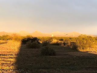
We have looked at a certain flat green area on the north side of Graham Mtn for several days. We finally figured out that this is Frye Mesa and there is a road going up it to a trail head. So today was the day to go explore it. The forecast had a small chance of rain this afternoon but we went anyway. The drive up Frye Mesa was pretty interesting. A narrow steep gravel road. We were very pleased that we didn't meet anyone on the road as turnouts were minimal.
Found some more cows and calves up there! They are just about everywhere. All roads have cattle guards somewhere, even US 70.
The trail went up an old road then took off up the mountainside and into Frye Canyon. But in a very familiar sounding story it lead to a stream crossing. The streams on the mountain are swollen with snow melt runoff. This crossing had some blowdowns on it and no obvious trail anywhere. We looked around for 15 minutes and decided to bag it. There was no way to cross with dry feet. So our day hike was only 2.6 miles. But the good part came when we got back to the truck and ate lunch... while the rain started. If we had found a crossing we would be out in the rain. At 45 degrees. Better this way!
Callahan was glad to see us early again!
We talk constantly about the COVID situation and our timing to go home. It is now clear that we do not want to be out here until it all blows over. That would take too long. So probably, and our thoughts change constantly, when I get the truck repaired we'll head on east. That could be another week. Given all the uncertainty of campgrounds being closed etc. we may take a fairly direct route that puts us home a couple weeks from now. Until we change our minds again!
 |
| Frye Mesa from Camp |
 |
| Approaching Frye Mesa |
 |
| Frye Mesa Reservoir |
 |
| More cows! |
 |
| Frye Mountain |
 |
| That's about how far we got |
 |
| red caterpillar! |
Headed down the Frye Mesa Road:
 |
| On top of Frye Mesa was a big flat grassland |
Sunset tonight was well above average!


No comments:
Post a Comment